September 28, 2026
Why a Car Became a Necessity: Lessons from Ontario’s Suburbs
How land-use planning has shaped transportation, housing, and the future of suburban communities
Introduction
Owning a car has become a necessity for many households across Southern Ontario. While public discussions often focus on traffic congestion, transit delays, or rising fuel prices, these issues are symptoms of a much larger planning challenge. The way communities are designed directly influences how people travel, where they choose to live, and how much time and money they spend reaching everyday destinations.
Over the past several decades, the Greater Toronto Area (GTA) has experienced rapid suburban growth. Regions such as Peel and Durham have accommodated significant population increases while providing new housing, employment lands, and economic opportunities. However, this growth has also reinforced development patterns characterized by lower densities, separated land uses, and increasing dependence on private automobiles.
As someone who has relied on public transit while living in both Mississauga and Whitby, I initially viewed transportation as the primary issue. Studying urban planning revealed a different perspective. Transit systems were not simply underperforming; they were operating within communities that had largely been planned around the automobile.
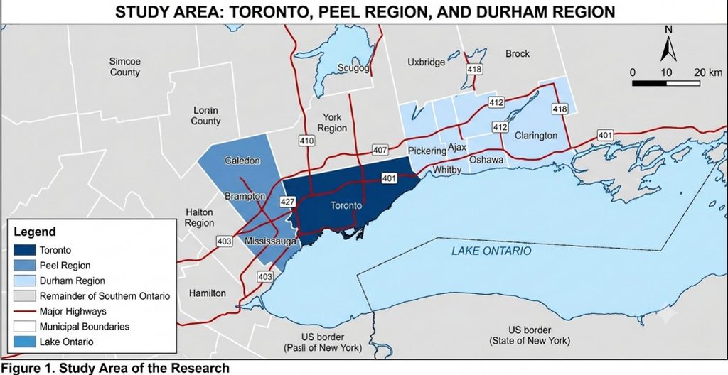
From Urban Centres to Expanding Suburbs
Ontario’s suburban landscape is largely the product of post-war planning priorities that emphasized homeownership, economic growth, and automobile mobility. As Toronto expanded throughout the second half of the twentieth century, development increasingly spread into surrounding municipalities, supported by extensive investments in highway infrastructure.
This pattern successfully accommodated rapid population growth and provided families with larger homes and more affordable housing opportunities. Yet it also produced communities where residential neighbourhoods, employment areas, shopping centres, schools, and recreation facilities were frequently separated by considerable distances.
Population density illustrates this transformation. Toronto remains significantly more compact than the surrounding suburban regions, while Peel Region represents an intermediate urban form and Durham Region reflects much lower overall density. These differences influence not only where people live but also how transportation systems operate and how efficiently public transit can serve growing communities.
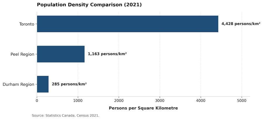
Lower-density development requires longer infrastructure networks, greater travel distances, and more dispersed transit routes. As neighbourhoods become increasingly spread out, providing frequent and convenient public transportation becomes considerably more challenging.
Recognizing these challenges, municipalities across the GTA have gradually shifted planning priorities toward intensification, mixed-use development, transit-oriented communities, and complete communities. These policies acknowledge that transportation performance cannot be separated from land-use planning.
Car Dependency Is a Planning Outcome
Automobile dependency is often described as a personal choice. In reality, planning decisions strongly influence whether residents have meaningful transportation alternatives.
Communities with higher densities, connected street networks, mixed land uses, and concentrated employment naturally support walking, cycling, and public transit. Conversely, dispersed development patterns increase travel distances and reduce transit efficiency, making private vehicles the fastest and often the only practical option for many trips.
This relationship is clearly reflected across the GTA.
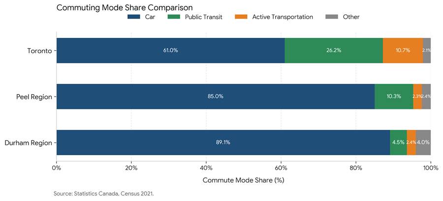
The contrast is striking. While Toronto maintains a comparatively balanced distribution of commuting modes, the overwhelming majority of workers in Peel and Durham Regions rely on private vehicles for daily travel. Transit and active transportation account for a much smaller share of commuting trips despite continued investments in regional transportation infrastructure.
This should not necessarily be interpreted as a failure of transit agencies. Instead, it demonstrates the close relationship between land-use planning and transportation demand. Transit systems perform best when supported by sufficient density, shorter travel distances, and a mix of residential, commercial, and employment uses.
Simply adding more buses or extending transit routes cannot fully overcome neighbourhoods that require residents to travel long distances between everyday destinations.
Housing Patterns Shape Transportation Choices
Housing discussions in Ontario frequently focus on affordability, supply, and rising prices. However, the type and location of housing also influence transportation behaviour.
Communities dominated by detached housing generally require more land per household, increasing the distance between homes, workplaces, services, and transit. In contrast, compact housing forms—including apartments, townhouses, and mixed-use residential developments—support higher densities, shorter travel distances, and more efficient public transportation.
The housing mix across the GTA demonstrates this transition from urban to suburban development.
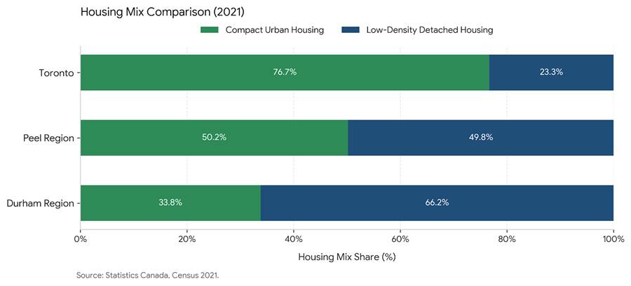
Toronto continues to be characterized by a diverse mix of higher-density housing, while detached dwellings become increasingly common moving toward suburban regions. This pattern is important because housing form directly affects infrastructure requirements, transportation demand, and the feasibility of active transportation.
Planning is therefore not only about providing additional housing but also about determining what type of housing is built, where it is located, and how it is connected to employment, services, parks, schools, and transit.
This concept forms the foundation of contemporary planning initiatives such as complete communities and transit-oriented development, which seek to reduce reliance on private vehicles while improving accessibility and quality of life.
Housing Affordability and the Transportation Trade-Off
One of the primary reasons households continue moving beyond Toronto is affordability. Housing costs remain substantially higher within the urban core than in surrounding municipalities, encouraging many residents to seek larger or less expensive homes farther from major employment centres.
At first glance, this appears to be a financial advantage. However, housing affordability cannot be evaluated independently of transportation.
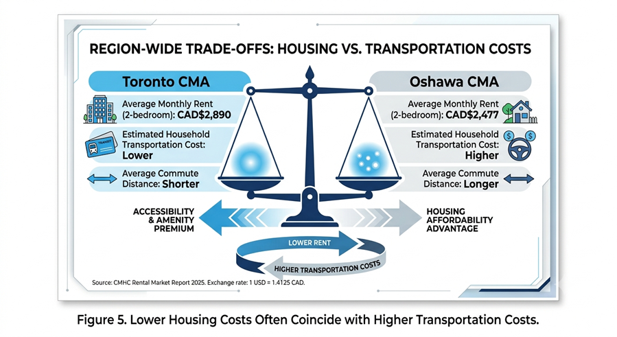
Although households may save on monthly housing costs, those savings are frequently offset by longer commuting distances, increased vehicle ownership, fuel expenses, insurance, parking, and maintenance costs. In many suburban communities, purchasing a vehicle becomes less of a lifestyle preference and more of an economic necessity.
For planners, this highlights the importance of evaluating combined housing and transportation costs rather than considering housing affordability in isolation. Communities that integrate housing, employment, public services, and transit can reduce both financial costs and travel time while creating more sustainable patterns of growth.
Time Poverty: The Hidden Cost of Car Dependency
Transportation planning is often measured by travel speeds, congestion levels, and infrastructure capacity. Yet one of its most significant impacts is far more personal: time. Every additional minute spent commuting is time unavailable for family, recreation, community participation, education, or rest.
For many suburban residents, longer commutes are an accepted part of everyday life. While improvements to highways may reduce travel times temporarily, increasing travel distances between homes, workplaces, and services often offsets these benefits over time.
The relationship between urban form and commuting becomes particularly evident across the Greater Toronto Area.
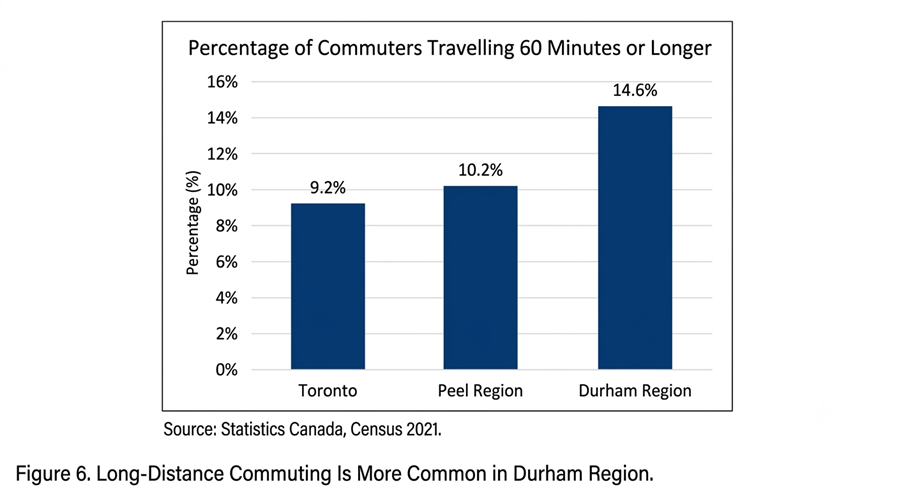
Durham Region records the highest proportion of long-distance commuters among the three study areas. Many residents travel considerable distances to employment centres in Toronto, Mississauga, Markham, or other municipalities, making automobile ownership essential for maintaining daily schedules.
This pattern illustrates what planners increasingly describe as time poverty. As commuting times increase, residents have fewer opportunities to engage in local businesses, volunteer activities, physical activity, or social interactions that contribute to healthy and resilient communities.
Reducing time poverty requires more than transportation investments alone. It depends on creating communities where housing, employment, education, recreation, healthcare, and daily services are located closer together. Mixed-use neighbourhoods, improved transit connections, and active transportation infrastructure can significantly reduce travel time while improving overall quality of life.
Understanding the Cycle of Automobile Dependency
Car dependency does not emerge from a single planning decision. Rather, it develops through a series of interconnected choices that reinforce one another over time.
Lower-density development spreads homes, workplaces, and services farther apart, increasing travel distances. As destinations become less accessible by walking, cycling, or transit, residents increasingly rely on private vehicles. Growing automobile use often leads to road expansions intended to relieve congestion. While these investments improve mobility in the short term, they also encourage additional low-density development, restarting the cycle.
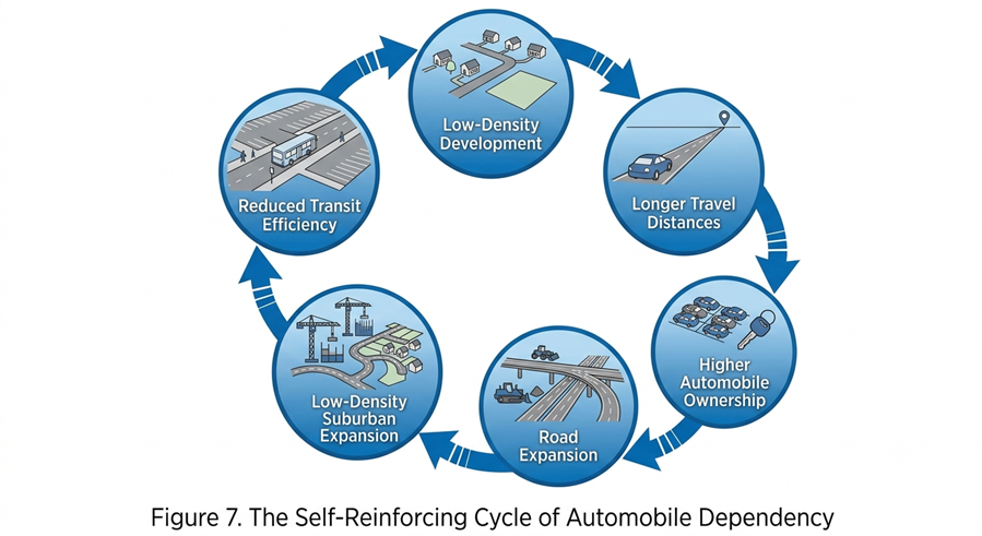
This feedback loop has been documented in planning literature for decades and helps explain why many growing suburban communities continue to experience congestion despite ongoing investments in highway infrastructure. Expanding road capacity can improve traffic flow temporarily, but unless land-use patterns also evolve, increasing numbers of residents and longer travel distances eventually restore previous congestion levels.
Breaking this cycle requires an integrated planning approach. Higher-density housing, mixed-use development, transit-oriented communities, complete streets, and connected active transportation networks all help provide practical alternatives to private vehicle travel.
Importantly, this does not mean eliminating the automobile. Cars will continue to play an important role throughout Ontario, particularly in rural and suburban communities. The objective is instead to provide residents with meaningful transportation choices so that driving becomes one option among many rather than the only practical means of mobility.
Highway 413: A Planning Debate Beyond Transportation
Few transportation projects in Ontario have generated as much discussion as the proposed Highway 413. While the project is frequently presented as a strategy to improve regional mobility and accommodate future growth, it also raises broader questions about land-use planning, environmental protection, and long-term development patterns.
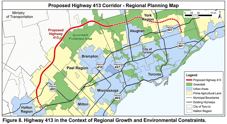
Supporters argue that Highway 413 could improve goods movement, reduce congestion on existing highways, and enhance connectivity between rapidly growing municipalities in Peel, Halton, and York Regions. Improved transportation infrastructure may also support economic development by increasing access to employment lands and industrial areas.
Critics, however, argue that additional highway capacity may encourage continued low-density suburban expansion, increase automobile dependency while placing greater pressure on agricultural land, natural heritage systems, and environmentally sensitive areas. As development extends outward, open spaces are often converted into residential subdivisions, commercial developments, and transportation corridors. This expansion can fragment ecosystems, reduce wildlife habitat and biodiversity, diminish the ecological services provided by natural landscapes, and permanently remove productive farmland from agricultural use. Others question whether new highways can provide lasting congestion relief without complementary changes to land-use planning.
Viewed through a planning lens, Highway 413 represents more than a transportation project. It highlights the need to coordinate infrastructure investments with growth management policies, environmental objectives, and sustainable urban development. Decisions about transportation infrastructure ultimately shape where communities grow and how residents travel for decades to come.
Planning the Way Forward: Building Communities with Choice
Understanding the causes of automobile dependency is only the first step. The greater challenge for planners is creating communities where residents have genuine transportation choices while continuing to accommodate Ontario’s growing population.
There is no single solution. Instead, reducing automobile dependency requires an integrated planning approach that coordinates land use, transportation, housing, and infrastructure investment.
- Encourage Compact, Mixed-Use Development
Future neighbourhoods should integrate housing, employment, retail, schools, healthcare, parks, and public spaces within walking distance. Compact development reduces travel distances, supports local businesses, and allows many daily trips to be completed without relying on a private vehicle.
- Prioritize Transit-Oriented Development
New residential and employment growth should be concentrated around higher-order transit corridors and major stations. Transit-oriented development increases transit ridership, improves service efficiency, and creates vibrant, walkable communities while reducing dependence on private automobiles.
- Diversify Housing Options
Addressing housing affordability requires more than increasing supply. Municipalities should provide a broader range of housing types including apartments, townhouses, multiplexes, and mixed-use residential buildings—to accommodate different household needs while supporting compact urban form.
- Invest in Active Transportation
Walking and cycling should become practical transportation options rather than recreational activities. Safe sidewalks, protected bicycle lanes, connected trail systems, and accessible public spaces improve mobility, public health, and environmental sustainability.
- Integrate Land Use and Transportation Planning
Roads, transit investments, housing, and employment areas should be planned together rather than as separate projects. Coordinated planning ensures that transportation infrastructure supports complete communities instead of encouraging continued outward suburban expansion.
- Protect Farmland, Open Space, and Natural Ecosystems
Protecting agricultural land, biodiversity, and natural ecosystems should remain a central objective of future growth management. As Ontario continues to grow, redevelopment, intensification, and strategic infill should be prioritized before expanding into undeveloped areas. Conserving farmland, forests, wetlands, and wildlife corridors not only protects ecological integrity but also preserves valuable ecosystem services such as flood mitigation, carbon sequestration, water filtration, and biodiversity. Compact growth enables communities to accommodate population increases while minimizing the loss of open space and reducing the environmental footprint of urban expansion.
Collectively, these strategies support Ontario’s vision of complete communities. Rather than eliminating the automobile, they expand transportation choices, allowing residents to decide whether walking, cycling, transit, or driving is the most appropriate option for each trip.
Artificial Intelligence: Supporting Better Planning Decisions
Emerging technologies are transforming many aspects of urban planning, and artificial intelligence (AI) is becoming an increasingly valuable tool for planners and municipalities.
Rather than replacing professional judgment, AI has the potential to strengthen planning by improving the analysis of complex datasets, identifying trends, and supporting evidence-based decision-making.
AI applications are already assisting transportation modelling, land-use forecasting, infrastructure management, climate risk assessment, and development review processes. By processing large volumes of information more efficiently, these technologies can help planners evaluate multiple scenarios, anticipate future growth, and allocate resources more effectively.
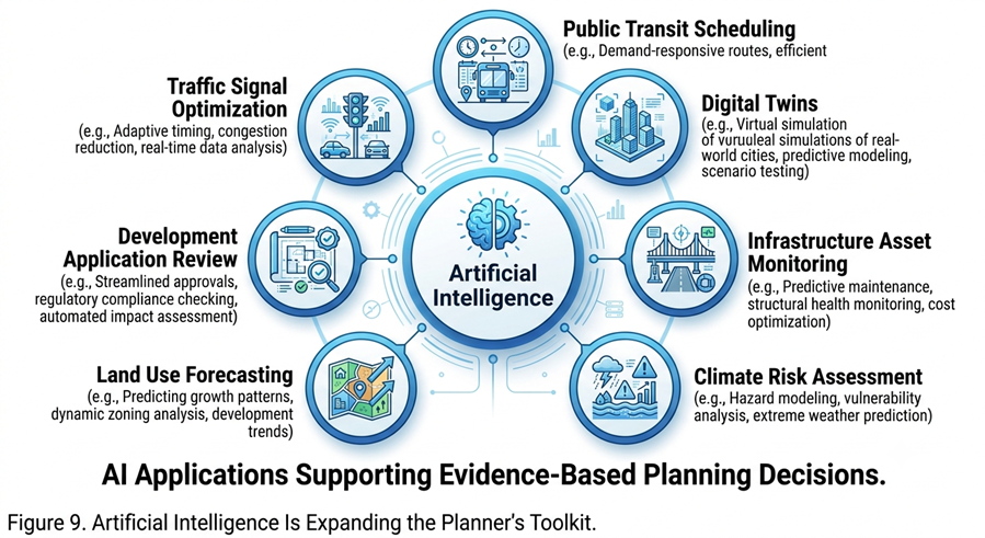
However, technology alone cannot solve planning challenges. Successful communities still depend on sound planning principles, meaningful public engagement, professional expertise, and policies that balance economic growth, environmental stewardship, and social equity.
Artificial intelligence should therefore be viewed as a tool that enhances planning practice rather than a substitute for thoughtful land-use decisions.
Conclusion
The increasing necessity of owning a car across many parts of Southern Ontario is not simply the result of individual preferences or inadequate transit service. It is largely a consequence of decades of land-use decisions that shaped neighbourhood density, housing patterns, street networks, and the location of everyday destinations.
The comparison between Toronto, Peel Region, and Durham Region demonstrates how differences in urban form influence transportation behaviour, housing choices, and commuting patterns. Lower-density suburban development has successfully accommodated population growth and expanded housing opportunities, but it has also reinforced reliance on private vehicles while increasing commuting distances and transportation costs.
Addressing these challenges requires an integrated planning approach rather than isolated transportation solutions. Complete communities, transit-oriented development, diverse housing options, and coordinated land-use and transportation planning provide opportunities to reduce automobile dependency while improving accessibility, affordability, and environmental sustainability.
As Ontario continues to grow, planners have an important opportunity to shape communities where residents can choose how they travel rather than being limited by how their neighbourhoods were designed. Emerging technologies such as artificial intelligence will strengthen planning practice, but lasting solutions will continue to depend on thoughtful planning decisions that place people, communities, and long-term sustainability at the centre of urban growth.
The views expressed in this blog post are those of the author(s), and may not reflect the position of the Ontario Professional Planners Institute.
Post by Yusuf Chana